Hiking Pocaterra Ridge
Pocaterra Ridge keeps growing in popularity year on year and it’s easy to see why! Even though it can be crowded at the weekends it still remains one of the best trails in Kananaskis country.

The ridge line fading into the distance.
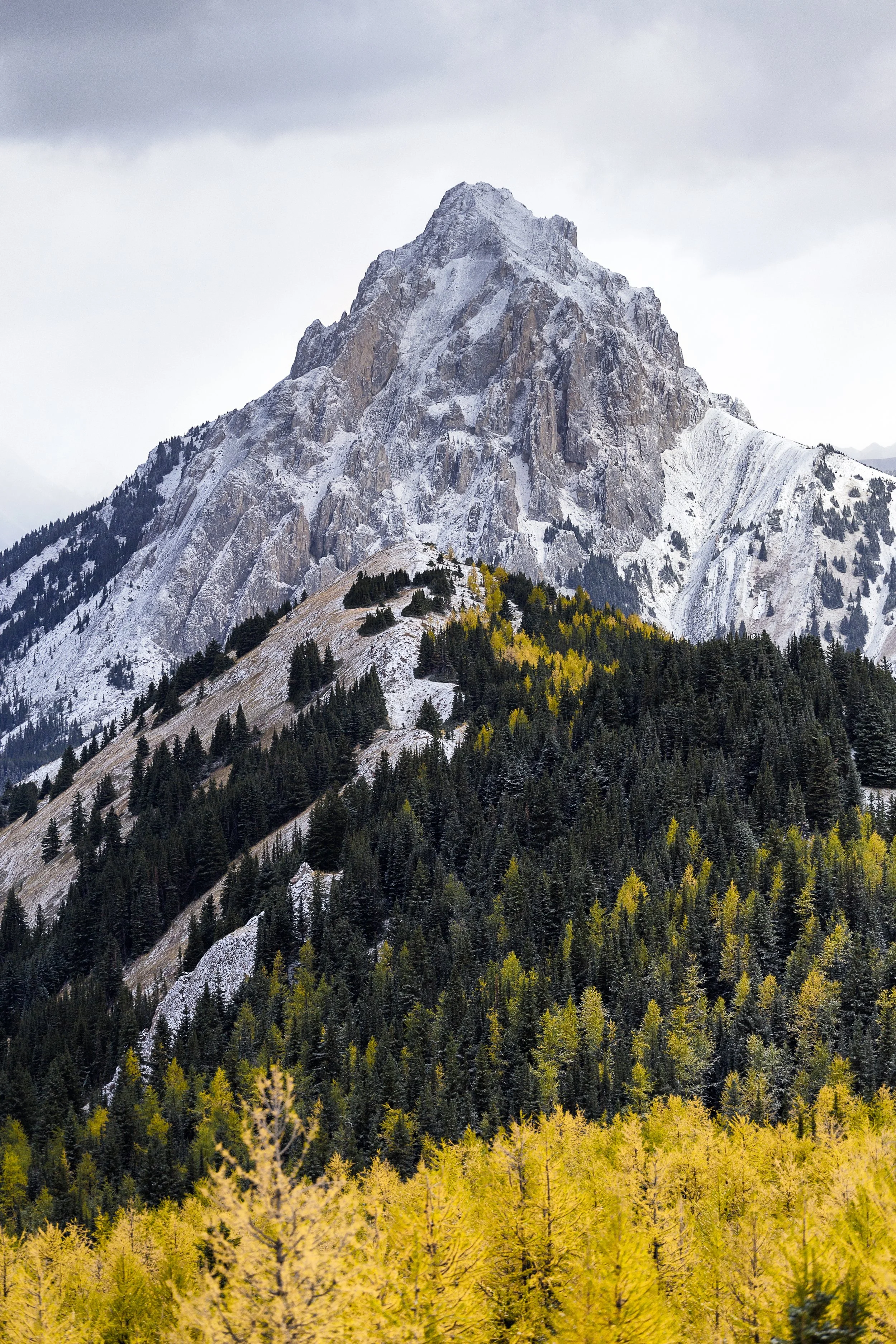
Larch Trees on Pocaterra Ridge
the stats
Time: 6 - 7 hours
Distance: 11 km point to point (You’ll need to either have two cars or hitch a ride back to the start point)
Elevation Gain: 730 meters
How To Get To The Pocaterra Ridge Trailhead
The trail is best started from the Highwood Pass parking lot, as this way you’ll minimise your up hill walking a little. This parking lot is on Highway 40 approximately 50 minutes south of the Trans Canada Highway. At the north end of the parking lot you’ll see a gravel trail, follow it across the foot bridge and you’ll see a sign asking that hikers keep to the established trails. The trail will be just to the left of the sign.
When’s the best time of year to hike Pocaterra Ridge?
The hiking season in Kananaskis is really from June to around the end of September. The season can start early and finish later though depending on the weather.
The Pocaterra trail starts on Highwood pass, the highest paved path in Canada at 2200 m. This means of course that the whole trail is at elevation so winter snow will hold on for a little longer in this region.
This road is only open to traffic from the 15th of June to the 30th of November and closed for wildlife outside of these dates. So realistically outside of those times you won’t be able to access the trailhead anyway.
Even though this trail is stunning at any time of year it really comes to life during larch season towards the end of September. As you can probably see from some of the images in this blog though is that the winter can certainly come early, especially on the pass, so don’t be surprised to see snow at that time of year.
Hiking Pocaterra Ridge
Pocaterra Ridge has to be one of my favourite trails in the Kananaskis region. In general Kananaskis is stunning but this ridge gives you the best vantage points of some of the most incredible peaks and rock formations you’ll ever see.
Once you’ve found the trail as described above you’ll be able to follow this path until you reach a small tarn. After this point the trail forks; left to Pocaterra Cirque and keep right to continue on to the ridge. The first ascent is the steepest of the trip but you are rewarded with incredible views.
From this point the trail is fairly obvious as you are simply following the ridge line up several other small summits.

In the foreground is the ridge line you’ll follow up and down to several smaller summits.
Once you’ve followed this ridge line for some time it will slowly start to descend into the woods. The trail is relatively straight forward and the ridge line runs pretty much parallel to Highway 40 the entire way and this is where you are looking to end your hike. If you’ve come out the right way you’ll be across the road from Little Highwood Pass parking lot. If you’ve managed to bring two cars you should look to leave one at each end to save yourself the walk back. If you only have one vehicle you’ll need to either walk the 7km or hitch a ride back to your start point.
This hike is most scenic during the fall where you have fields of larch trees adding even more to the impressive scenery. However at this time of year weather can be even more unpredictable than usual so be prepared for snow, wind, rain, heat and more!

The larch trees add to an already stunning landscape.
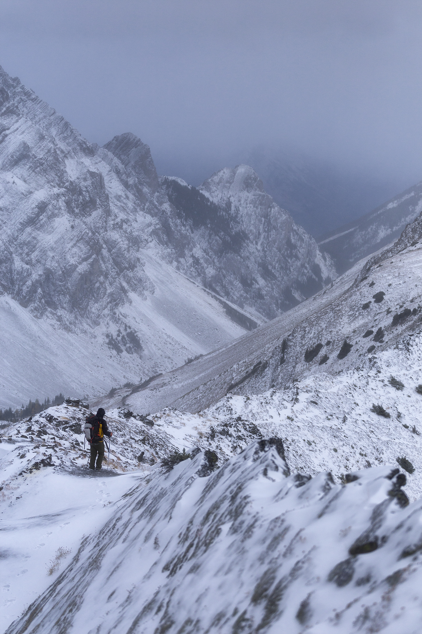
A blizzard sets in as we make our way along the ridge.
Looking for More Hikes in Kananaskis?
Tent Ridge offers stunning views, ridge line hiking and incredible fall colour.
East End of Rundle has to be one of my favourite for sunset photography.
Sarrail Ridge has to be one of the best views in Kananaskis Country!
Yates Mountain offers a great early season warm up to the hiking season!
Pipers Passis a lesser known unofficial trail.
Things to know Before You Go
Parks and Conservation Passes: Whether you’re hiking in a national park in Canada or certain provincial parks you’ll most likely need some kind of conservation pass. A Discovery Pass will cover you for the year for all national parks in Canada whilst the Kananaskis Conservation Pass covers the provincial and wildland parks in the Kananaskis region.
Check Trail Conditions Before You Go: Trail conditions in the Rockies can change month to month and year to year. Trails close for wildlife, weather and avalanche hazards. Be sure to double check trail conditions before heading out to avoid any disappointment. You can do so here!
Leave No Trace: When hiking anywhere in the world it’s important that you practice a leave no trace philosophy. This means whatever you hike in to a trail or campground you have to be able to hike out too. There won’t be trash cans or waste disposal in the backcountry and you should never throw trash in any out houses or pit toilets. In recent years, as trails and parks become busier, litter is becoming more of a problem. Don’t add to that problem!
Bears and Wildlife! Wild life is everywhere in the Canadian Rockies, even on trails that are close to town. People and animals have been attacked by bears and other wild life on popular trails in the past so don’t take it for granted.
Most wildlife is looking to avoid human contact so no matter what type of wildlife you see be sure to keep your distance. 30 metres is the minimum recommendation for most species but under any circumstance don’t approach wildlife. Even the cuddliest of critters can be dangerous!
So as always be bear aware, make noise, hike in groups, carry bear spray and, if they’re allowed on trail, keep your dog on a leash!
Offline maps knowing where you’re going is super important as to not get lost. I recommend All Trails Plus for finding routes and offline mapping allowing you to safely find your way home.
Interested in other multi-day hikes in the Canadian Rockies or maybe day hikes?